Prof. Said Abubakar
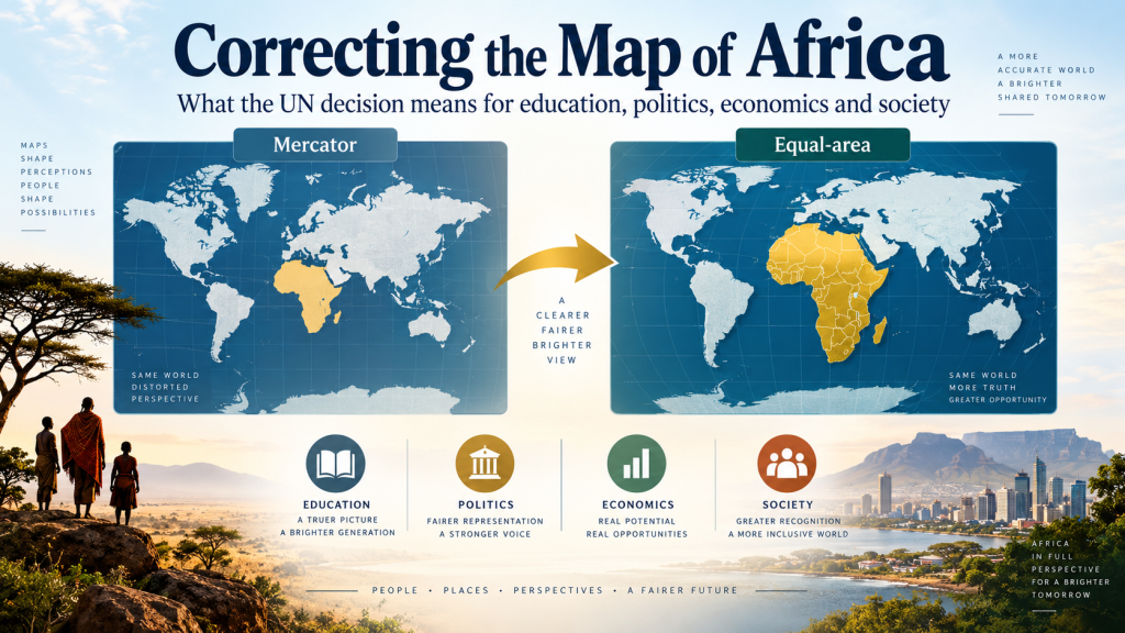
On 4 September 2026, the United Nations General Assembly overwhelmingly supported the “Correct the Map” resolution, championed by Togo on behalf of the African Group. The resolution encourages governments, educational institutions, publishers and technology companies to use map projections that represent Africa and other regions more accurately. It does not redraw Africa’s borders or change the continent’s physical size; rather, it addresses distortion in how Africa has traditionally appeared on many world maps.
For centuries, the widely used Mercator projection has greatly enlarged areas nearer the poles while making equatorial regions appear relatively smaller. Consequently, Africa has often looked much smaller in comparison with Greenland, Europe, Russia and North America than its actual land area would suggest. The difference is striking. Africa covers approximately 30.4 million square kilometers. It is roughly three times the size of Europe and about fourteen times the size of Greenland. The Equal Earth projection is designed to preserve the relative areas of continents much more accurately than Mercator.
What Could This Change Mean for Africa?
1. Educational Dimension
The greatest immediate impact may be in education. Maps are among the first tools children use to understand the world. If the map itself gives a distorted impression of geographical size, students may develop an inaccurate mental picture of continents and their relative importance. The UN resolution could encourage schools, universities, textbook publishers and educational technology providers to introduce equal-area maps into geography and social-science education. Togo has already indicated its intention to revise school geography materials. This provides African education systems with an opportunity not simply to replace one map with another, but to teach students why different map projections exist, how they influence perception, and how geographical knowledge has developed historically. More accurate maps could therefore strengthen geographical literacy while contributing to a broader reconsideration of how Africa is presented within school curricula.
2. Political Dimension
The political significance is largely symbolic but important. For generations, a huge continent containing more than fifty countries has been visually presented in ways that can make it seem considerably smaller in relation to northern regions. Correcting that representation can reinforce Africa’s demand for fair representation and greater recognition in global affairs. The African Union welcomed the resolution as an important step toward fairer and more accurate cartographic representation. However, the change should not be misunderstood. It does not provide African countries with additional territory, additional UN votes, new international borders or greater legal sovereignty. Its political influence comes primarily through perception, identity and representation. A more accurately represented Africa may strengthen the message that the continent should not be treated as peripheral to global decision-making.
3. Economic Dimension
Changing a map will not automatically increase Africa’s GDP, employment, international trade or investment. Nevertheless, geographical perception can influence how people understand economic opportunities. When Africa is shown at its actual relative scale, it becomes easier to appreciate the enormous distances, resources, markets and infrastructure requirements involved in developing the continent. Africa’s true geographical scale highlights the importance of investments in transport corridors, energy networks, digital connectivity, agriculture, regional trade and cross-border infrastructure. It can also reinforce awareness of the potential importance of African economic integration. A continent of such enormous geographical scale should increasingly be viewed not merely as a collection of fragmented markets but as a major global economic region. Therefore, the map itself does not create economic development, but accurate geographical understanding can contribute to better economic perceptions and strategic thinking.
4. Social and Psychological Dimension
Maps are not simply geographical instruments. They also influence identity and perceptions of importance. When generations of African children repeatedly see their continent represented as relatively small, that visual representation can become part of how they unconsciously understand Africa’s position in the world.
Using more proportionate maps may strengthen geographical confidence among younger generations and encourage them to recognize the actual scale and diversity of their continent.
This is particularly relevant in discussions about African identity, cultural confidence and decolonizing education. This means presenting geographical reality more faithfully.
5. Cultural and Historical Dimension
The debate also raises important questions concerning the relationship between knowledge, history and representation. The Mercator projection was developed in the sixteenth century and remains extremely useful for navigation because it preserves local angles and directions. The problem arises when it is treated as though it provides an accurate comparison of the physical areas of countries and continents. The new discussion therefore provides an opportunity for Africans and the wider world to distinguish between a map designed primarily for navigation and a map intended to communicate relative geographical area. Correcting the map should consequently be understood not as rejecting all previous cartography, but as choosing the appropriate map projection for the educational or analytical purpose.
Conclusion
The UN’s support for correcting the representation of Africa on world maps should not be interpreted as changing Africa’s actual size or redrawing its borders. Africa has not become larger; its geographical representation is becoming more accurate. The most important consequences may be educational, cultural and psychological, while political and economic impacts are likely to emerge indirectly over time. A useful way of understanding the potential transformation is: Accurate Map → Accurate Education → Better Geographic Awareness → Changed Perceptions → Stronger African Identity → Greater Recognition of Africa’s Political and Economic Importance Maps influence how societies understand the world. Correcting geographical distortion is therefore not merely about cartography; it is also about education, knowledge, representation and global perception.